Use the map
Object cards and map key
Selecting an object opens a card that blends fixed catalogue facts with values recomputed for your selected place, date and time.
What every card carries
Where relevant, a card includes right ascension and declination, and the current altitude and azimuth for the selected observer. A clear warning appears when a selected target sits below the calculated horizon. That warning is about geometry: an object above the line may still be hidden by your real horizon, weather or light pollution.
Stars
A star card opens with basic identification, apparent magnitude, celestial coordinates and current local position. When extended HYG data is available it can also show proper name or Bayer/Flamsteed designation, HIP, HD, HR and Gliese identifiers, constellation, spectral type, distance in parsecs and light-years, absolute magnitude, luminosity, radial velocity, proper motion and variability. Extended information is loaded from the bundled catalogue; a short loading notice can appear while it opens.
Deep-sky objects
Cards for galaxies, globular clusters, open clusters, planetary nebulae, nebulae and supernova remnants give the object class, catalogue designation and common name where available. They list apparent magnitude, angular dimensions, position angle for galaxies when provided, RA, declination, local altitude and azimuth. These entries draw on OpenNGC.
Sun and Moon
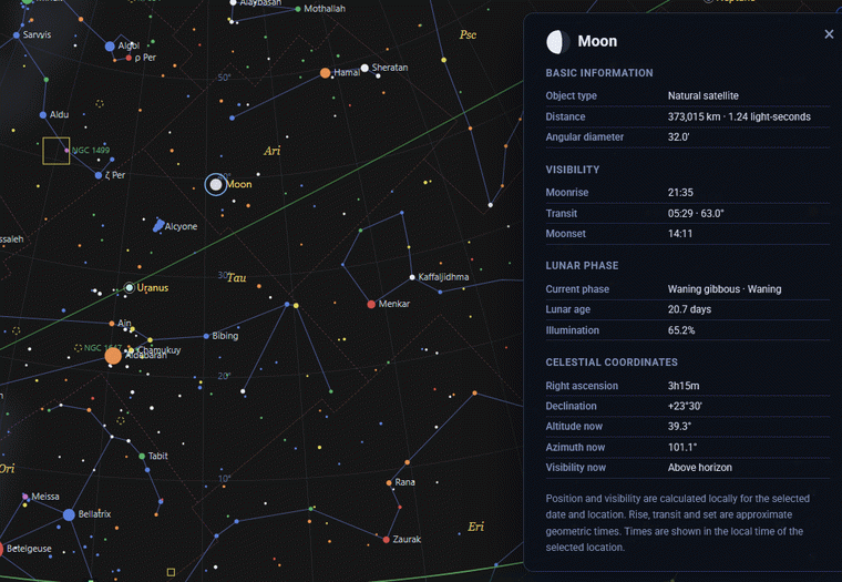
The Sun card gives distance, angular diameter, apparent magnitude, sunrise, solar transit, sunset and the civil, nautical and astronomical dawn and dusk, together with coordinates and local position. The Moon card gives distance, angular diameter, moonrise, transit, moonset, phase name, waxing or waning status, lunar age, illuminated fraction, coordinates and local position. Times are shown in the time zone of the selected observing location and are calculated values.
Planets
A planet card ties the current calculated view to reference data. It shows distance, angular diameter, illuminated fraction and phase angle, rise, transit and set, RA, declination, altitude and azimuth. Physical and orbital sections add planet number, class, notable feature, mean diameter, mass, density, surface gravity, rotation period, orbital period and mean distance from the Sun. The current position is calculated in the browser; the reference physical values follow NASA/JPL tables.
Meteor showers and constellations
A meteor-shower card shows IAU/IMO code, active or inactive status for the selected date, activity range, annual peak, reference ZHR, geocentric speed, population index, reference radiant and current local altitude and azimuth. ZHR is an idealised reference rate, not a local forecast. A constellation card gives the IAU abbreviation, the label-centre coordinates and the current local position. The constellation-abbreviations tool lists all IAU codes with their full Latin names.
Map key
The right-side map-key button opens a compact legend. In spectral-colour mode, O/B stars run blue to blue-white, F/G stars trend yellow-white to yellow, and K/M stars run orange to red. The deep-sky key distinguishes globular clusters, galaxies and planetary nebulae; the map also uses data for open clusters, nebulae and supernova remnants where present. The magnitude scale is a reminder that smaller or negative numbers mean brighter stars, and that symbol size changes with brightness in magnitude mode.
Because local values depend on the selected setup, confirm the observer location and date and time before interpreting them. For a target shortlist, continue to the observation planner.